
|
|
|
|
Lesson 2: Functions of our company (ctd.)
|
[Page 2.7] |
|
Air Navigation Service Function |
|
|
Unlike the Airport Services Function which is mainly concerned with things that happen on ground, the ‘Air Navigation Services Function’ is concerned with planes in flight and planes about to take flight. |
|
|
|
|
|
|
|
‘Navigation’ is a frequently used word in Aviation. Its simple meaning is ‘finding your way to reach a destination’. For example, if you want to come to BIA setting off from Ja-ela, you may choose to travel on the E01 expressway in which case you must first come to the Ja-ela/Pamunugama interchange, then get into the expressway and proceed to fall into the Canada Friendship Road. Alternatively you could choose to travel along the Colombo-Chillaw highway towards Negombo, then turn right at the 18th post junction to get into the Canada Friendship Road. In either case, there are various cues (indicators) along the way that would confirm to you that you are on the right path. For example, if you are travelling along Colombo-Chillaw highway and if you forgot to take the right turn at 18th post junction, you will reach other landmarks which will tell you that you are on the wrong path. Then you would have to turn back. Now, selecting one of several routes to reach your destination, travelling along the selected route, using various land marks to change directions and to verify whether you are on the correct path are all parts of navigation. |
|
|
|
|
|
|
|
When we navigate along the ground, apart from selecting the appropriate route, we also use visual cues to avoid collision with others travelling along the same route. For example, if we approach a vehicle travelling ahead of us, we slow down to avoid running into it and perhaps overtake it when possible. Once again it is our ability to visually see the obstacle that help us to get around it. This is also a part of navigation. |
|
|
|
|
|
|
|
More formally, navigation refers to the process of monitoring and controlling the movement of an object to make it reach a predetermined destination along a desired path avoiding collision with obstacles. As already seen from the example, visual cues along the way such as road signs and landmarks help us when we navigate on ground. |
|
|
|
|
|
|
|
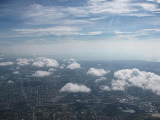
For a plane flying thousands of feet above the ground, there are no visual cues like that. So the pilots cannot make decisions about the route the plane should take, using visual cues. When a plane is about 35,000 feet above ground you may not even see the ground and even if you could, it would be a very high altitude view from which you cannot pick any cues to navigate.
|
|
|
|
How the ground is seen from 35,000 feet above. Clouds often obscure even this. (Picture source: www.travelcodex.com)
|
|
|
|
At the same time there are hundreds of other planes up in the air flying towards their own destinations. It is necessary for these planes to be able to fly safely without colliding with each other. |
|
|
|
|
|
|
|
So, how does a pilot cope? |
|
|
|
|
|
|
|
The pilot cannot cope with these challenges on its own. It must be helped from the ground. |
|
|
|
|
|
|
|
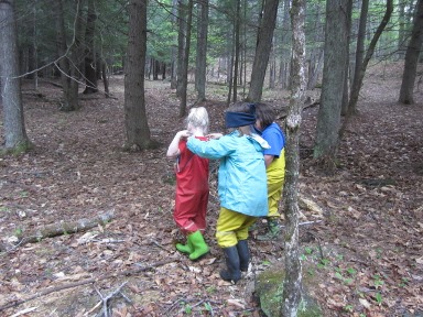
To understand this, let’s take an example of a person who is blindfolded walking inside a building. Someone who can see him can direct him to walk, stop, turn, climb up and down and direct him to reach a required place inside the building. Although the blindfolded person cannot see anything, by listening to a ‘trustworthy partner’ and following his directions, the person can still reach the required place in the same manner that he would have if he was able to see.
|
|
|
|
Without being able to see, navigation requires help from those who can (picture source:www.mrsminnucci.wordpress.com)
|
|
|
|
Pilots are more or less like that blindfolded person who cannot figure out their way on their own. So they must be helped by ‘trustworthy partners’ called ‘Air Traffic Controllers’ on ground who are able to “see” the aircraft. The word “see” as used here should not be taken literally. When we say that the Air Traffic Controller is able to see the plane, it does not always mean that he can see the plane visually with his naked eye. That is possible only within a very limited range when the plane is close to the airport. At other times, the plane is seen indirectly. There are various technologies available to create an artificial image that the Air Traffic Controller can see which is as good as actually seeing the plane. Alternatively, the Air Traffic Controller can use certain data about the flight and create a mental image that he can use to help the plane navigate. In either case the Air Traffic Controller is able to see what the pilot cannot see. He would provide the necessary directions to the pilot from ground using radio communication. Using these directions provided by the Air Traffic Controller, the pilot can navigate the plane along the desired route, avoiding collisions to reach the destination. |
|
|
|
|
|
|
|
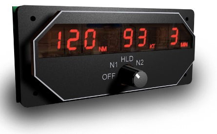
In addition to the navigation directions provided by Air Traffic Controllers, there are certain equipment located at ground that provide useful information to the pilot directly, using radio signals. For example there is an instrument in the plane that shows the pilot how far away the airport that he is flying to is located. It is called the ‘Distance Measuring Equipment’ (DME). The DME indication gradually reduces as the plane approaches the airport thus indicating to the pilot that he is on the correct path. The DME works by having a constant dialog between the equipment in the plane and the equipment on ground, using radio signals. The DME is a Navigational Aid or ‘Nav Aid’. There are many other ‘Nav Aids’ that provide other useful information for the plane to navigate.
|
|
|
|
DME readout in cockpit, enables pilot to see how far he is from destination (Picture source: www.flightillusion.com)
|
|
|
|
Using the directions provided by the Air Traffic Controller and the indications provided by the Nav Aids, the pilot can navigate safely in air without being able to see any visual cues on ground. This is what is called ‘Air Navigation’. The services provided from ground for the pilot to perform ‘Air Navigation’ of the plane are collectively called ‘Air Navigation Services’. |
|
|
|
|
|
|
|
‘Air Navigation Services’ usually include the following: |
|
|
|
|
|
|
|
|
|
|
|
We will look at each of these separately but before that let us understand two more related things which we will often refer to in the coming lessons. |
|
|
|
|
|
|
|
Air Navigation Service Provider (ANSP) |
|
|
|
|
|
|
|
An organization or body that provides Air Navigation Services is called an Air Navigation Service Provider or an ANSP. The ANSP is the employee of the staff engaged in providing Air Navigation Services and the owner or the custodian of the equipment used at ground to support the Air Navigation Services function. Usually ANSP are owned by governments but there are a few privately owned ANSP as well as public-private partnered ANSP in the world today. |
|
|
|
|
|
|
|
Flight Information Region (FIR) |
|
|
|
|
|
|
|
There is an air space assigned to each ANSP and the ANSP is responsible for the safe passage of planes flying across that air space through the effective and efficient provision of Air Navigation Services. These air spaces are called Flight Information Regions (FIRs). FIRs could be very large and they border each other. The entire global air apace could be considered as a maze of FIRs that do not overlap (no gaps in between). Every FIR is surrounded by its neighbouring FIRs and an air route will generally go through a number of FIRs. At any given phase of a flight, the plane is served by the ANSP assigned to the FIR through which the plane is currently flying.
|
|
|
|
The FIR that Sri Lanka is located in is the ‘Colombo FIR' (learn more and see map). Our company is the ANSP serving the Colombo FIR. |
|
|
| Next, we will look at Air Navigation Services in detail. | <Top |
Powered by IT Division for delivery by the VTW CATC © AASL All Rights Reserved